|
Eureka,
in the extreme northwest corner of Montana, was first named
Deweyville after Ed Demers’ wife’s maiden name. The first
buildings were on the banks of the Tobacco River. The town began
building up the hill. A large sawmill, which supported the economy
of the town, burned down in 1923; since then, the residents have
developed a flourishing Christmas tree market. Huckleberries grow in
abundance on the hillside. (from Cheney’s Names on the Face of
Montana, Mountain Press Publishing Company)
Eureka was known as the Tobacco
Plains and was originally home to the Kootenai Indians. The northern
section of US Highway 93 was originally an Indian trail and was
later used by fur traders and pack trains for travel between
Missoula and Vancouver, B.C. David Thompson was the first white man
to see the area in 1808. Homesteaders began to come in the 1880s.
The first buildings were built on the banks of the Tobacco River. In
1923 a large sawmill, which supported the town's economy burnt down.
Since then the area has become a great supplier of Christmas trees.
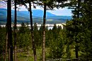
This area offers some of the state's
scenic treasures tucked away in Montana's northwest corner. Tobacco
River Campground is located adjacent to the Tobacco River in a
natural forested area. It is also in the vicinity of 90-mile-long
Lake Koocanusa and The Hoodoos, a limestone formation found in an
adjoining bay off the lake. Ten Lakes Scenic Area treats visitors to
mountain drives, pristine lakes and abundant fishing. For area
history, visit the Tobacco Valley Historical Village. It is a unique
collection of buildings and various structures from the 1880s to
1920s.
Elevation: 2,566 feet.
VisitMT.com
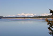
Lake Koocanusa cuts a narrow
fjord-like gorge between the Purcell Mountains and the Salish
Mountains. The lake provides excellent fishing and boating
opportunities. Picnicking sites, overnight camping, ball fields, a
swimming beach, and boat ramps are available here as well as summer
tours of Libby Dam, which is located approximately 43 miles south of
Rexford at Lake Koocanusa.
Lake Koocanusa Scenic Byway, in the
Kootenai National Forest in northwestern Montana, follows the
Kootenai River and Lake Koocanusa via State Highway No. 37. Open
year-round, this 67-mile route connects Libby and Eureka, traveling
right through Rexford. Rock outcrops and ledges provide habitat for
bighorn sheep, seen frequently along the byway. Numerous hiking
trails in the Kootenai National Forest intersect the byway and a
100-mile circular bicycle tour begins at Libby Dam.
Eureka is also located near Ten Lake
Scenic Area of the Kootenai National Forest, which offers more than
89 miles of trails of remote backpacking and hiking opportunities
through rugged terrain with spectacular mountain views reaching into
Canada. High alpine mountains, cool clear high mountain lakes,
peaceful meandering trails, all combine to make Ten Lakes Scenic
Area a backpacker's and angler’s delight.
|